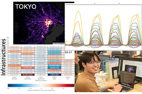
In the recent years, hourly-varying population datasets of high spatial-resolution have become available with the advancement of remote sensing. Through a collaborative project (Institute of Science and Tohoku University) aimed at disaster management, we were able to use the Docomo MSS datasets that allow us to inspect 500-m time-variations of populations over Japan.
Together with the students and through the undergraduate efforts of Thanakrit Yoongsomporn (a.k.a. Bank), we were able to construct an index (called “Daytime Human Mobility Index”, DHMI) that enable seasonal-dependent regional mapping of daytime human inflow and outflow levels of 500-m neighborhood grids.
A paper has been published in Urban Science that details the procedure and demonstration of the features of the DHMI over the Greater Tokyo Area. Multiple years were inspected including years covering the COVID-19 pandemic. For further details, refer here.